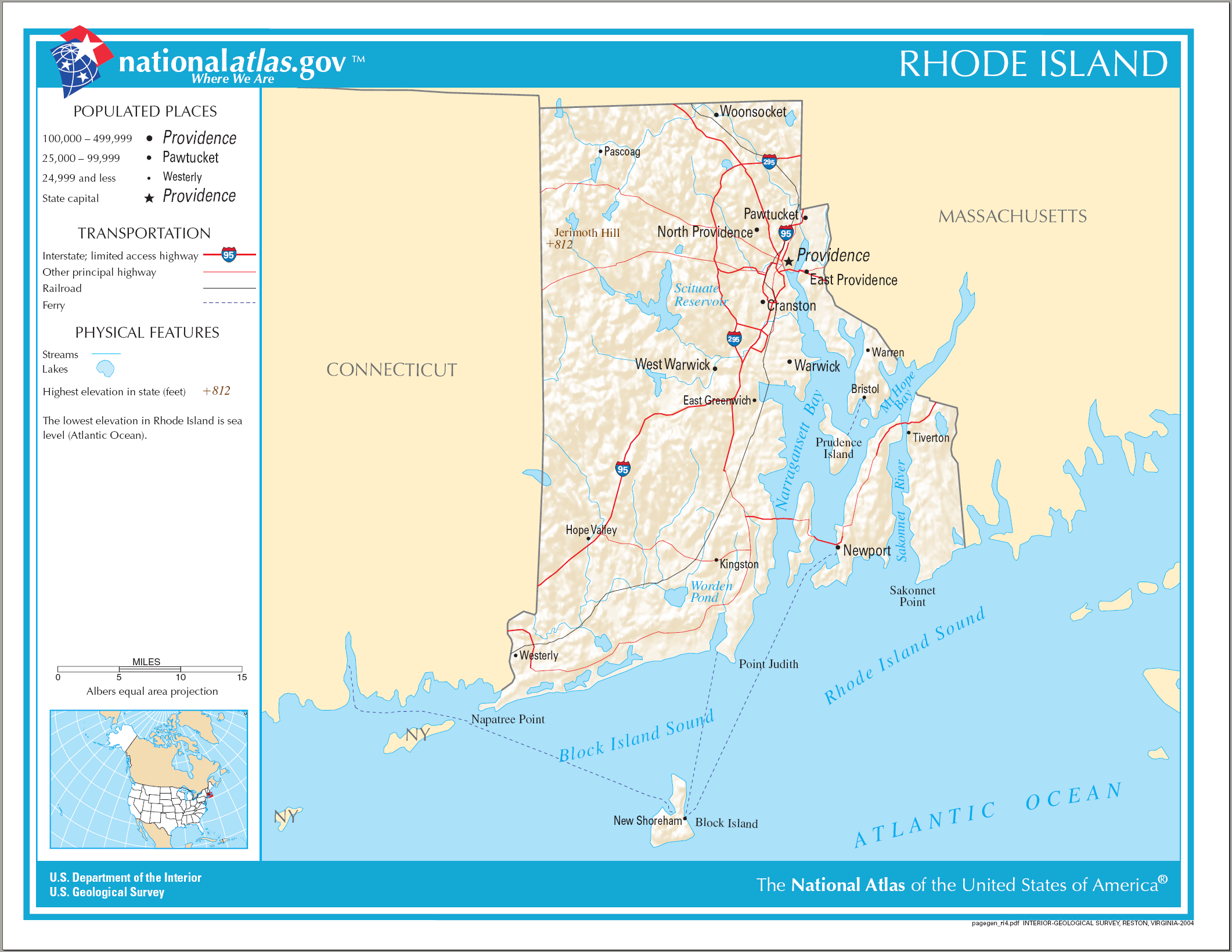
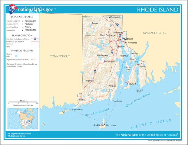
Plaetje:Map of Rhode Island NA.png
Grootte van deze voorvertoning: 776 × 600 pixels. Andere resoluties: 311 × 240 pixels | 621 × 480 pixels | 994 × 768 pixels | 1.280 × 989 pixels | 2.122 × 1.640 pixels.
Volledige resolutie (2.122 × 1.640 pixels, bestandsgroôtte: 822 kB, MIME-type: image/png)
Saemenvattieng
| Beschrijving |
English: National Atlas map of Rhode Island. |
| Datum | |
| Bron | National Atlas |
| Auteur |
Licentie
This map was obtained from an edition of the National Atlas of the United States. Like almost all works of the U.S. federal government, works from the National Atlas are in the public domain in the United States.
Online access: NationalAtlas.gov | 1970 print edition: Library of Congress, Perry-Castañeda Library
|
Bestandsgeschiedenisse
Klik op 'n datum/tied om 't bestand te zien zoas 't van d'r tied woas.
| Datum/tied | Miniatuur | Ofmetiengen | Gebruker | Opmerkienge | |
|---|---|---|---|---|---|
| hudige versie | 17 apr 2015 14:16 | | 2.122 × 1.640 (822 kB) | RokerHRO | optipng -o7 -i0 → 18.34% decrease |
| 15 oes 2006 08:22 |  | 2.122 × 1.640 (1.007 kB) | Huebi~commonswiki | {{Information| |Description=Map of Rhode Island |Source=[http://www.nationalatlas.gov National Atlas] }} Category:Maps of the United States Category:Maps of Rhode Island {{PD-USGov-Atlas}} |
Bestandsgebruuk
Dit bestand òdt op de volgende pagina gebruukt:
Globaal bestandsgebruik
De volgende andere wiki's gebruiken dit bestand:
- Gebruikt op ang.wikipedia.org
- Gebruikt op be.wikipedia.org
- Gebruikt op ca.wikipedia.org
- Gebruikt op de.wikipedia.org
- Gebruikt op en.wikipedia.org
- Gebruikt op fi.wikipedia.org
- Gebruikt op ga.wikipedia.org
- Gebruikt op gl.wikipedia.org
- Gebruikt op hu.wikipedia.org
- Gebruikt op hy.wikipedia.org
- Gebruikt op ja.wikipedia.org
- Gebruikt op ko.wikipedia.org
- Gebruikt op lt.wikipedia.org
- Gebruikt op mhr.wikipedia.org
- Gebruikt op mr.wikipedia.org
- Gebruikt op os.wikipedia.org
- Gebruikt op sw.wikipedia.org
- Gebruikt op tg.wikipedia.org
- Gebruikt op tt.wikipedia.org
- Gebruikt op www.wikidata.org