Plaetje:Map of Oregon NA.png

Grootte van deze voorvertoning: 800 × 541 pixels. Andere resoluties: 320 × 217 pixels | 640 × 433 pixels | 1.024 × 693 pixels | 1.280 × 866 pixels | 1.967 × 1.331 pixels.
Volledige resolutie (1.967 × 1.331 pixels, bestandsgroôtte: 2,15 MB, MIME-type: image/png)
Saemenvattieng
| Beschrijving |
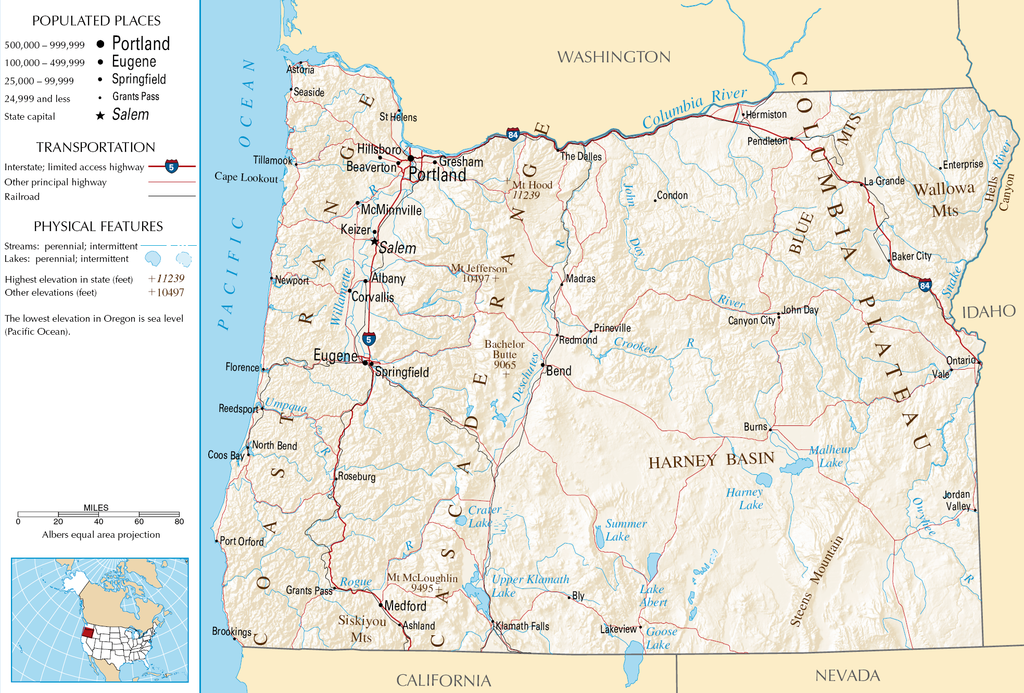
English: Topographic map of the geography of Oregon — with major rivers shown.
|
| Bron | National Atlas |
| Auteur | Onbekend |
Licentie
This map was obtained from an edition of the National Atlas of the United States. Like almost all works of the U.S. federal government, works from the National Atlas are in the public domain in the United States.
Online access: NationalAtlas.gov | 1970 print edition: Library of Congress, Perry-Castañeda Library
|
Bestandsgeschiedenisse
Klik op 'n datum/tied om 't bestand te zien zoas 't van d'r tied woas.
| Datum/tied | Miniatuur | Ofmetiengen | Gebruker | Opmerkienge | |
|---|---|---|---|---|---|
| hudige versie | 16 okt 2007 05:46 | | 1.967 × 1.331 (2,15 MB) | Peteforsyth | removed extraneous text and logo from public domain image |
| 15 oes 2006 08:13 |  | 2.122 × 1.640 (2,75 MB) | Huebi~commonswiki | {{Information| |Description=Map of Oregon |Source=[http://www.nationalatlas.gov National Atlas] }} Category:Maps of the United States Category:Maps of Oregon {{PD-USGov-Atlas}} |
Bestandsgebruuk
Dit bestand òdt op de volgende pagina gebruukt:
Globaal bestandsgebruik
De volgende andere wiki's gebruiken dit bestand:
- Gebruikt op als.wikipedia.org
- Gebruikt op ar.wikipedia.org
- Gebruikt op de.wikipedia.org
- Gebruikt op en.wikipedia.org
- Gebruikt op eo.wikipedia.org
- Gebruikt op fi.wikipedia.org
- Gebruikt op fr.wikipedia.org
- Gebruikt op hr.wiktionary.org
- Gebruikt op hsb.wikipedia.org
- Gebruikt op hu.wikipedia.org
- Gebruikt op incubator.wikimedia.org
- Gebruikt op is.wikipedia.org
- Gebruikt op it.wikipedia.org
- Gebruikt op ja.wikipedia.org
- Gebruikt op kk.wikipedia.org
- Gebruikt op lt.wikipedia.org
- Gebruikt op mr.wikipedia.org
- Gebruikt op nds-nl.wikipedia.org
- Gebruikt op pa.wikipedia.org
- Gebruikt op ru.wikipedia.org
- Gebruikt op sw.wikipedia.org
- Gebruikt op vi.wikipedia.org