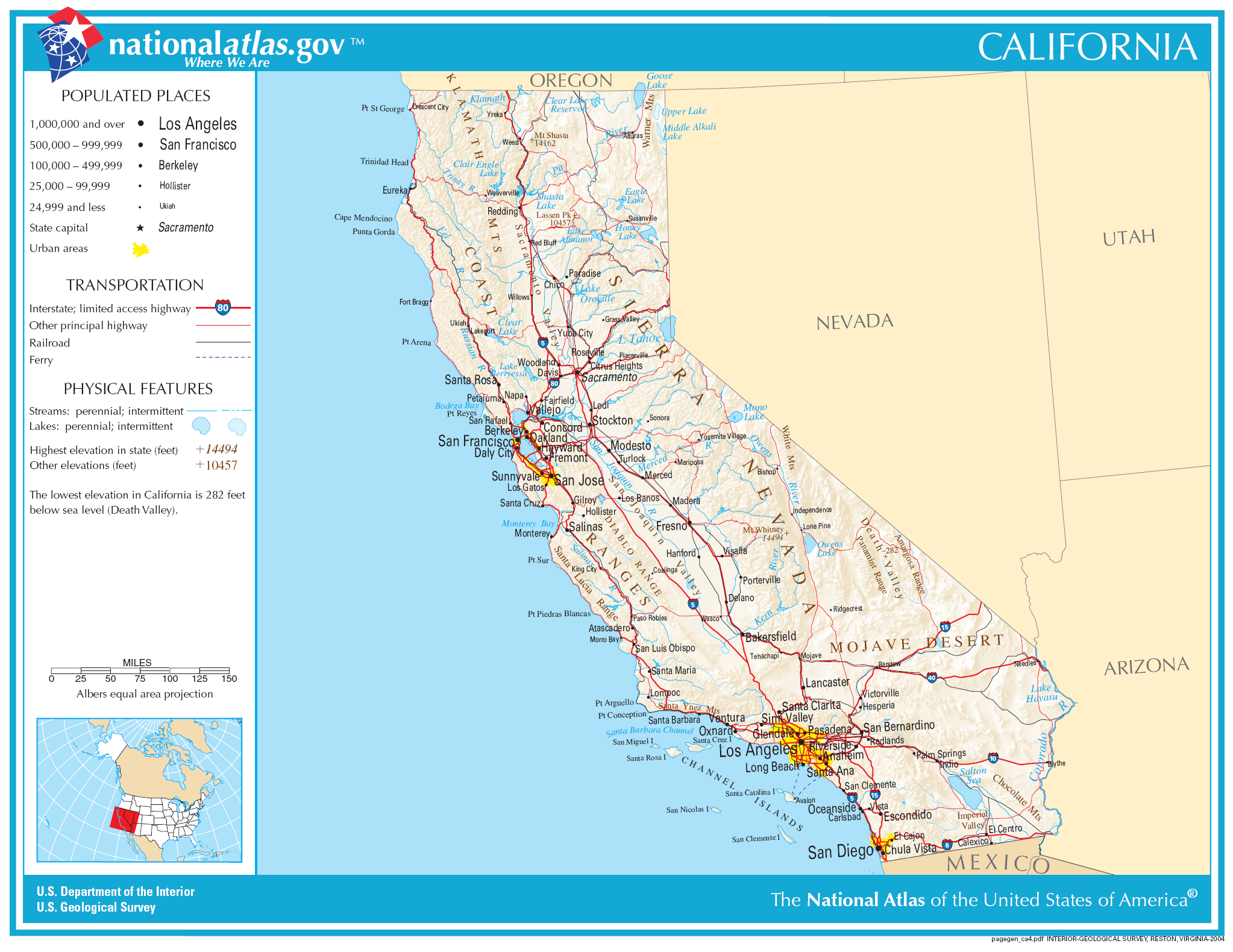
Plaetje:Map of California NA.png
Grootte van deze voorvertoning: 777 × 600 pixels. Andere resoluties: 311 × 240 pixels | 622 × 480 pixels | 995 × 768 pixels | 1.280 × 988 pixels | 2.046 × 1.579 pixels.
Volledige resolutie (2.046 × 1.579 pixels, bestandsgroôtte: 1,48 MB, MIME-type: image/png)
Saemenvattieng
| Beschrijving | |
| Datum | |
| Bron | |
| Auteur | National Atlas of the United States |
| Toestemming (Hergebruik van dit bestand) |
Public domain |
Licentie
This map was obtained from an edition of the National Atlas of the United States. Like almost all works of the U.S. federal government, works from the National Atlas are in the public domain in the United States.
Online access: NationalAtlas.gov | 1970 print edition: Library of Congress, Perry-Castañeda Library
|
Bestandsgeschiedenisse
Klik op 'n datum/tied om 't bestand te zien zoas 't van d'r tied woas.
| Datum/tied | Miniatuur | Ofmetiengen | Gebruker | Opmerkienge | |
|---|---|---|---|---|---|
| hudige versie | 30 nov 2006 06:34 | | 2.046 × 1.579 (1,48 MB) | Jengod | Crop to reduce excess whitespace on border |
| 14 oes 2006 20:19 |  | 2.122 × 1.640 (1,55 MB) | Huebi~commonswiki | {{Information| |Description=Map of Valifornia |Source=[http://www.nationalatlas.gov National Atlas] }} Category:Maps of the United States Category:Maps of California {{PD-USGov-Atlas}} |
Bestandsgebruuk
Dit bestand òdt op de volgende pagina gebruukt:
Globaal bestandsgebruik
De volgende andere wiki's gebruiken dit bestand:
- Gebruikt op als.wikipedia.org
- Gebruikt op be-tarask.wikipedia.org
- Gebruikt op bh.wikipedia.org
- Gebruikt op ca.wikipedia.org
- Gebruikt op de.wikipedia.org
- Gebruikt op en.wikipedia.org
- Gebruikt op eo.wikipedia.org
- Gebruikt op fa.wikipedia.org
- Gebruikt op fo.wikipedia.org
- Gebruikt op hi.wikipedia.org
- Gebruikt op hsb.wikipedia.org
- Gebruikt op hu.wikipedia.org
- Gebruikt op id.wikipedia.org
- Gebruikt op ilo.wikipedia.org
- Gebruikt op incubator.wikimedia.org
- Gebruikt op it.wikipedia.org
- Gebruikt op ja.wikipedia.org
Globaal gebruik van dit bestand bekijken.