Plaetje:Map of Alabama NA.png

Grootte van deze voorvertoning: 776 × 600 pixels. Andere resoluties: 311 × 240 pixels | 621 × 480 pixels | 994 × 768 pixels | 1.280 × 989 pixels | 2.122 × 1.640 pixels.
Volledige resolutie (2.122 × 1.640 pixels, bestandsgroôtte: 1,61 MB, MIME-type: image/png)
Saemenvattieng
| Beschrijving |
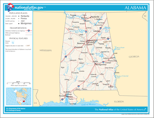
English: Map of the U.S. state of Alabama, with full legend area, copied from the National Atlas of the United States in high resolution form (1.61 megabytes). |
| Datum | (uploaded on 14 auhustus 2006) |
| Bron | |
| Auteur | National Atlas of the United States (uploaded by User:Huebi) |
| Andere versies |
The map has some related variations:
|
Licentie
This map was obtained from an edition of the National Atlas of the United States. Like almost all works of the U.S. federal government, works from the National Atlas are in the public domain in the United States.
Online access: NationalAtlas.gov | 1970 print edition: Library of Congress, Perry-Castañeda Library
|
Bestandsgeschiedenisse
Klik op 'n datum/tied om 't bestand te zien zoas 't van d'r tied woas.
| Datum/tied | Miniatuur | Ofmetiengen | Gebruker | Opmerkienge | |
|---|---|---|---|---|---|
| hudige versie | 14 oes 2006 20:08 | | 2.122 × 1.640 (1,61 MB) | Huebi~commonswiki | {{Information| |Description=Map of Alabama |Source=[http://www.nationalatlas.gov National Atlas] }} Category:Maps of the United States Category:Maps of Alabama {{PD-USGov-Atlas}} |
Bestandsgebruuk
Dit bestand òdt op de volgende pagina gebruukt:
Globaal bestandsgebruik
De volgende andere wiki's gebruiken dit bestand:
- Gebruikt op als.wikipedia.org
- Gebruikt op bs.wikipedia.org
- Gebruikt op ca.wikipedia.org
- Gebruikt op de.wikipedia.org
- Gebruikt op en.wikipedia.org
- Gebruikt op hi.wikipedia.org
- Gebruikt op hr.wiktionary.org
- Gebruikt op hsb.wikipedia.org
- Gebruikt op hu.wikipedia.org
- Gebruikt op ilo.wikipedia.org
- Gebruikt op it.wikipedia.org
- Gebruikt op ja.wikipedia.org
- Gebruikt op ko.wikipedia.org
- Gebruikt op no.wikipedia.org
- Gebruikt op or.wikipedia.org
- Gebruikt op simple.wikipedia.org
- Gebruikt op si.wikipedia.org
- Gebruikt op uz.wikipedia.org