Plaetje:Luxemburg Topographisch.png

Grootte van deze voorvertoning: 364 × 599 pixels. Andere resoluties: 146 × 240 pixels | 292 × 480 pixels | 467 × 768 pixels | 1.216 × 2.000 pixels.
Volledige resolutie (1.216 × 2.000 pixels, bestandsgroôtte: 3,56 MB, MIME-type: image/png)
| Beschrijving |
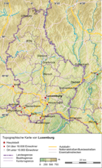
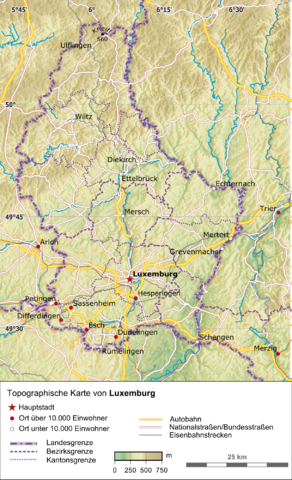
Deutsch: Topographische Karte von Luxemburg |
|||
| Datum | ||||
| Bron |
Eigen werk, using:
|
|||
| Auteur | Carport | |||
| Toestemming (Hergebruik van dit bestand) |
Dit bestand is gelicenseerd onder de Creative Commons-licentie Naamsvermelding-Gelijk delen 3.0 Unported
|
Bestandsgeschiedenisse
Klik op 'n datum/tied om 't bestand te zien zoas 't van d'r tied woas.
| Datum/tied | Miniatuur | Ofmetiengen | Gebruker | Opmerkienge | |
|---|---|---|---|---|---|
| hudige versie | 15 dec 2012 13:40 | | 1.216 × 2.000 (3,56 MB) | Carport | {{Information |Description={{de|Topographische Karte von {{w|Luxemburg|3=de}}}} |Source={{own}}, using: * OpenStreetMap data * SRTM-3 data for the background * The {{w|Generic Mapping Tools}} for geocoding |Date=2012-12-15 |Author={{u|Carport}} |Pe... |
Bestandsgebruuk
Dit bestand òdt op de volgende pagina gebruukt:
Globaal bestandsgebruik
De volgende andere wiki's gebruiken dit bestand:
- Gebruikt op de.wikipedia.org
- Gebruikt op rm.wikipedia.org
- Gebruikt op uk.wikipedia.org